Home
Ren's Biking Blog
Ren With A Sat-Nav?
Blog Date 3 April 2022
Regular readers will know I have a certain degree of resistance to using Satellite Navigation systems. And yet it has come to light I have been making use of these items. Forsooth and verily, it seems I am a hypocrite and the worm might have turned.
Firstly, why am I (or was I) resistant to them? While I may lack many skills in many areas, I appear to have been blessed with at least a modicum of ability when it comes to basic navigation. Please don't misunderstand me, I'm no homing pigeon or continent crossing migratory butterfly. I have been painfully lost more times than I dare to recall. And yet, compared to my peers, I seem to have an edge in being able to find my way around.
Well photography ain't my forte is is.
While some folks can write beautiful poetry, others can see complex scientific formulas being solved in their mind's eye, I am able to store and process basic outline maps, it's an innate ability. Add to this many years and many miles of cold, hard practice and my powers have reached the dizzying heights of being "a bit better than the average person".
I fear that by using the modern digital co-driver I may lose these powers. If you don't use it, you lose it. Practice, lots and lots of practice, is the only thing that sets me apart from the rest.
Also. Some of the best places I've been have been to were found when I was desperately lost. For example I never planned to end up in one of the most beautiful places I've ever been, but finding the French edge of The Alps was one of the best mistakes I've made.
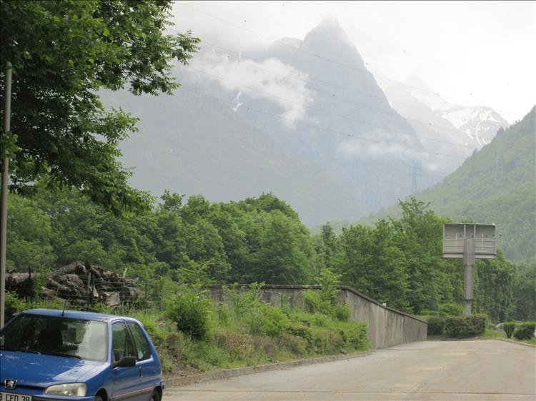
Hopelessly and wonderfully lost.
But. And there is always a but. Equally, perhaps even more so, I have been desperately and frustratingly, angrily and occasionally dangerously lost. In a strange town, late in the evening, perilously seeking a campsite, fearful of sleeping in a bush while making questionable riding errors due to misguided attention. This, this is truly when I wished an angel with a guiding light would lead me to the safety of a reception area and a toilet.
Age mellows a person. I'm remarkably average in so many ways that I clung (and still cling) to my one ability, thus refusing the benefits modern technology could offer. I have started to get over this, I am learning to find a balance.
By all means Ren, practice. *DO* look at maps, *DO* try to find your own way, *DO* remain being at ease with being lost and *DO* find fabulous places purely by accident. Equally *DON'T* be afraid to ask for help be it human or digital as and when and if this self navigation is no longer fun or helpful. When you've reached the point of angst and frustration - nav-up!
I am of the opinion that an Android phone with Google maps is the best option. Why? Today data is cheap and here in the UK at least coverage is very good. Alongside up-to-date maps Google maps also has live traffic updates which may keep you out of a very long queue. The system works and works well.
There are downsides. My cheap phone is not waterproof so if it's raining it ends up in a clear sandwich bag. If you do find yourself without data because you've gone off-piste then you are, frankly, screwed until you find data again. The ultimate solution is to use Google maps but keep a self-contained second option (such as Co-Pilot or Waze etc etc) installed and updated along with a waterproof phone.
Hang on a minute!! Maybe the keen eyed among you may one day notice a Garmin mount on my bars! What the deuce?!?! Fear not dear reader, fear not. A gentleman I am amicable with has recently purchased a smart new Garmin, making his old one redundant. Rather than bin it he kindly offered it to me. A free sat-nav? Er, ok then thanks.
It *IS* waterproof and it is a proper nav. I'm currently swapping between my phone, the Garmin and my innate abilities. Why?
Practice. Much like navigation without sat-nav takes constant practice, so does actually using a sat-nav. They are, when you're not used to them, VERY distracting. I am having to learn to use it as a tool rather than an obsession. To glance at it occasionally and focus on the road rather than watch the little rider going around corners with me. To learn that "third exit" may not be obvious on the street sign. To learn that 160 metres is not this turning here but that one over there. To understand if nothing is presented on the screen I am to follow the main road ahead.
And to not panic when I realise I'm in the wrong lane. I can, if it is not safe to change lanes, just take the wrong bleeding lane into the wrong bleeding turning and Mrs Google or Mr Garmin will calmly, politely and kindly help me correct the error of my ways. This in of itself is wonderful.
Yes. I have not one but 2 sat-navs. This is the ridiculous world in which we find ourselves.
If you'd like Ren to test and review your sat-nav contact ren@bikesandtravels.com
Reader's Comments
ROD¹ said :-
I use an old car TomTom.
I have sealed the edge of the screen with silicone and taped up the speaker in an attempt to make it waterproof.
I also found that it fits neatly into a flora tube, which keeps the rain off and helps a little in stopping the sun so I can read the screen.
Along with Google maps on my phone as a backup this has served my needs, as I only really use it when I am close to my destination.
Recently I have felt the need to plan routes with waypoints, to avoid main roads on the 125s, and this setup has very limited capabilities for this function.
I am looking at the beeline nav unit, does anyone use this system?
04/04/2022 09:11:05 UTC
Upt'North ¹ said :-
Rod, I'm obviously a bit like your good self.
I tend to only use the MapsMe when struggling to either find an overnight stop or for getting out of cities etc. But only as a last resort. Usually with ear plugs so I don't have to study the screen too much.
I think the Beeline looks interesting and far less distracting than eye level maps. I would wonder if it needs live data?
The problem I have with sat nav is I believe it to be inefficient and overly distracting. If you ever use one in an area you already know they will send you on some strange complex routes for no apparent reason.
The Beeline does look simple and would be very useful when lost, hungry, stupid or all three, but I wouldn't be interested if it needed live data.
Upt'North.
04/04/2022 11:53:59 UTC
Upt'North ¹ said :-
Plus...
I do like a map. Paper one.
04/04/2022 11:55:51 UTC
ROD¹ said :-
My understanding is that the beeline needs WiFi/data to set the route but then works offline with GPS/Bluetooth.
It can also be used to just show the direction as the crow flies to the destination.
04/04/2022 12:42:00 UTC
Upt'North ¹ said :-
So going back to point three above.....
You can load the route onto presumably your mobile on WiFi then disable WiFi/Data once loaded and on the road.
Sounds good. And I do like the simple graphics.
Go on Rod, take one for the team, get one bought....we know you want too.
Upt'North.
04/04/2022 12:54:14 UTC
Borsuk said :-
I use an astrolabe.
Only joking, I am much more up to date, I use my sextant. Bit of a bummer when it is raining though.
05/04/2022 00:59:48 UTC
Ian Soady¹ said :-
Asfar as I can see beeline is an expensive gadget that just has an arrow on it. Or am I missing something? It doesn't seem to be a low-cost or even cheap option to me. Reviews are not glittering. I'll stick with copilot.
I don't do European tours any more (at least on the bike) but when I did I was always happy with the IGN 1:1000000 map (for France - Michelin for others) in the tankbag map pocket. But I never had any fixed destinations - just a direction I wanted to go in till I was tired and needed to stop for coffee / food / a bed for the night.
I did use copilot on the maxi-scoot when delivering it to its proud new owner last week and that worked very well.
05/04/2022 17:03:31 UTC
Upt'North ¹ said :-
Ian, me o'd cock sparrow.
Can we take it from the post that you are firing up the mobile shed sometime soon? France perhaps?
Upt'North.
05/04/2022 20:31:35 UTC
Ian Soady¹ said :-
Ferry booked to Ouistreham for June. Fingers crossed we'll make it!
06/04/2022 09:57:26 UTC
Upt'North ¹ said :-
Ouistreham, Google, Google.
Ah, never heard of it Ian, good luck with your plans.
Upt'North.
06/04/2022 15:55:56 UTC
Ian Soady¹ said :-
For some reason the ferry company (Brittany) call it Caen although it's about 12 miles from there.
We don't plan to go far - a couple of weeks or so in the area north of the lower Loire. Or something else depending on how we feel.
06/04/2022 16:25:58 UTC
Ren - The Ed¹ said :-
Brittany Ferries huh. While I'm hardly a bastion of the left wing socialist movement I'm none too keen on the notion of travelling with P&O ferries for a while. Primarily due to their treatment of the (previous) staff but I'm not entirely convinced with the idea of sailing with a bunch of underpaid novices either. Ships are pretty safe - as much due to good staff as ship design.
06/04/2022 16:34:51 UTC
Upt'North ¹ said :-
Probably not the place to be political/moral Ed, but........
P and O won't be getting my money anytime soon, although for those that have already booked there will be little choice.
I'm no socialist, actually I don't think I'm anything ending in ist, except motorcyclist. But now more than ever we need decent standards in this upside down world. Thank the lord for sites like this where folk are good and decent.
Vive la revolution.
Upt'North.
06/04/2022 20:32:34 UTC
Bogger said :-
I'm off to France on the C125 in June. Opted to go with DFDS. Newhaven to Dieppe. Only £75.00 return.
Bogger
06/04/2022 20:51:18 UTC
Ren - The Ed¹ said :-
Sharon and I used the Newhaven - Dieppe route when we went to Honfleur. It works, nothing special or amazing but it works as it should which is nice. It's also not far from my dad's place so we have a convenient stay-over there too.
07/04/2022 08:34:34 UTC
Ian Soady¹ said :-
One of the many nice things about Brittany ferries is that they sail under the French flag rather than the Bahamas or other flag of convenience and their staff are all French and I assume work under French labour laws which of course are far better than ours......
I did actually look at Newhaven - Dieppe for our trip this summer as they do some very cheap caravan deals but decided against as I loathe the M25 which we'd have to use plus the cheap ferry lands at about 3 in the morning......
07/04/2022 10:30:14 UTC
Ross said :-
I’ve been thinking about some form of satnav for the bike recently so this topic is of interest to me. I’ve used Google maps on my phone in the car a few times and it’s seemed to work fairly well but I find I need the spoken directions as much, if not more than, the moving map when it’s busy and I don’t want my eyes to stray from the road for too long. Do folks use some form of headset in their helmets for this or just rely on the visuals…if a headset any recommendations? Also have heard stories of the vibration wrecking the image stabilization in mobile phones, so I’m thinking about buying a cheap used android phone and looking for recommendations as to which is the preferred app for mainly UK use? Does that sound like a sensible approach? I don’t want to splurge loads on a purpose made satnav that I’m only going to use occasionally!...then I suppose I’d need to hook something up to charge the phone on the bike…plus a holder of some sort on the ‘bars…it soon adds up don’t it!...might be easier to stay at home! :)
13/04/2022 10:57:16 UTC
Upt'North ¹ said :-
Ross,
Firstly, don't stop at home you'll just annoy people....
I put my mobile in the clear pocket in the tank bag and use the provided ear speaker thingymabobs, the wired ones.
It works just fine but the phone will get hot in the sun and turn itself off. Not ideal in a busy Italian town with everyone in more of a rush than you. Ask me how I know. Doh....
This will not probably be a problem in Wales. Or Bolton.
A cheap phone sounds a good idea but get plenty of gigawhatsits, I'm thinkin at least 32 and probably 64 for the downloaded maps. Try MapsMe.
Upt'North.
13/04/2022 12:46:44 UTC
Ian Soady¹ said :-
Copilot maps for the whole of the UK & RoI are less than 500MB so space isn't really a problem especially if you're using it as a dedicated satnav. One problem I came across is that earlier versions of android aren't compatible with later versions of copilot (and possibly others). Although I was using android 4.xx which is probably obsolete even by Ren's standards.
I would probably go for bluetooth earphones if I wanted voice prompts as they avoid getting tied up in wires but on the 1 occasion I used copilot on the bike I found the visual display fine.
13/04/2022 16:20:27 UTC
Ross said :-
Thanks chaps, I'll check out the copilot app. I'm in town later this week so I'll have a trawl around the secondhand electronics shops to see if I can find a suitable phone! Any thoughts on a suitable cheap mount for attaching to the handlebars?
20/04/2022 09:59:57 UTC
ROD¹ said :-
I use a phone mount from halfords totally waterproof £12.00
20/04/2022 11:31:51 UTC
Bogger said :-
Ren, ref the mounting system for your second hand phone. Can I suggest a used lollipop stick and some gaffer tape. Because this will be infinitely better than what you will conjure up.
Bogger......Happy to help
20/04/2022 12:45:33 UTC
Ren - The Ed¹ said :-
Thanks for your kind, helpful and heartfelt comment Bogger. Pfffffft.
ROD - show us ya phone mount so we know which one you mean.
20/04/2022 13:26:29 UTC
ROD¹ said :-
Phone mount link.
https://www.halfords.com/cycling/cycling-technology/phone-cases/halfords-waterpr...
20/04/2022 14:21:04 UTC
Name
Comment
Add a RELEVANT link (not required)
Upload an image (not required) -
Uploading...
Home
Ren's Biking Blog